Urban transport 1900s
Finding a route on the Underground in 1908
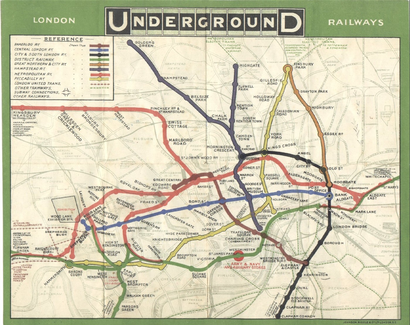
London’s Underground did not begin as one neatly unified system. Separate railway companies built routes, stations and identities that passengers had to piece together. The 1908 map brings underground railways onto a common sheet while retaining streets and the Thames as geographical guides. It belongs to the years before Harry Beck’s famous diagram changed the balance between location and connection. For a passenger, the practical question was already familiar: which line reaches the right station? The map captures a network becoming easier to recognise as a single part of London’s everyday life.
About the picture
The blue Central London route runs toward Bank across a recognisable street map. Keeping surface geography helps relate stations to the city, but it also crowds the centre. Later designers would make a different trade-off, simplifying geographical distances to give connections and interchanges more room.
The history behind it
What the source establishes
Knowing the modern Underground can be a disadvantage when it replaces reading the actual record. This 1908 map uses company names and a network that must be interpreted on its own terms. Its blue Central London line provides the requested through route to Bank, while the yellow Piccadilly service is a close but incorrect central-London alternative. The streets and Thames give geographical context, but distance on a drawing is not a timetable. A route can be established from this packet; an exact journey duration, fare or present-day platform arrangement cannot.
Dates, places and close alternatives
The source dates the map 1908, before the later diagrammatic convention named in the alternatives. The blue Central London route joins the named origin and destination through Oxford Circus. Geographical context and the legend help interpret a historical network, but they do not supply exact service times.
Reconstruct the network on the map’s own terms
A historical route task begins with the legend and dated station sequence, even when the system’s name remains familiar today. Trace the destination backward to the origin, then check the sequence in the direction of travel. Do not turn a crossing of strokes into an interchange without the map’s appropriate indication. A geographical background supplies context, while a separate timetable or fare record is needed for an operational promise.
A few things to read next
Books for a longer visit, and a few good places to start online. These are ordinary links, with no affiliate commission.
On the bookshelf
Underground: How the Tube Shaped London
Connects the railway network with the growth and daily life of London.
Mr Beck’s Underground Map
Read about the later diagrammatic redesign and compare it with this earlier geographical map.
Fire and Steam: How the Railways Transformed Britain
Places the Underground within Britain’s wider railway history.
Read online
London Underground
A starting point for names, dates and related subjects. Follow its references when you want to go further.
Underground maps: important editions
An official chronology that identifies the significance of the 1908 integrated map.
How Harry Beck revolutionised the Tube map
Follow the later change from geographical mapping to the familiar diagram.
Where the pictures come from
The original records and their individual rights statements are below. The pictures have not been generated or altered for the game.
London Underground railways map, 1908.
Historical London Underground map, Wikimedia Commons · 1908
Public domain: anonymous UK work published more than 70 years ago; also published before 1931 in the United States.
History notes and reading lists prepared for Then & Found with AI assistance. The source institutions and authors are not sponsors or endorsers. Suggest a correction or another source


