Exploration cartography 1500s
The Cantino planisphere and travelling knowledge
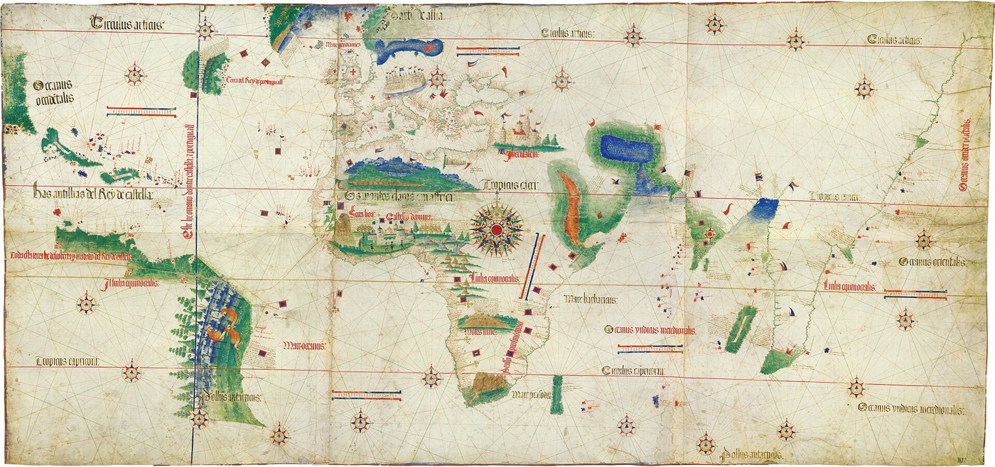
In 1502, geographical information could be a valuable diplomatic possession. The chart now called the Cantino planisphere brought together Portuguese knowledge of African coasts, Atlantic lands and routes reaching toward the Indian Ocean. Alberto Cantino obtained it in Lisbon and sent it to his patron in Ferrara. Its anonymous maker drew on accumulated reports and charts, rather than one person’s travels. The surviving parchment is now in Modena. Its Italian collecting history and Portuguese production context sit beside a much wider history of encounters, commerce and imperial ambition represented on the sheet.
About the picture
The dense coastal naming contrasts with the more selective treatment of inland territory. That imbalance reflects the importance of maritime routes and reported landfalls to the chart’s makers. Decorative figures and flags also place political claims inside the geographical picture, making the chart more than a neutral outline of shorelines.
The history behind it
What the source establishes
The chart is a record of assembled knowledge at a particular historical moment. Its 1502 date, detailed coasts and maritime linework support an early-sixteenth-century compilation incorporating information from different voyages and regions. None of that requires the anonymous cartographer to have personally observed everything drawn. The catalogue also separates origin from custody: a Portuguese chart can survive in an Italian library. That distinction defeats a tempting but unsound geographical attribution based entirely on where an artifact happens to be stored today.
Dates, places and close alternatives
The source date is 1502, an early-sixteenth-century artifact rather than a later reconstruction. Portuguese creation context and Modena custody are different facts, both supported by the catalogue. Rhumb lines and combined coastlines support a nautical compilation; they do not document one maker’s circumnavigation.
Track creation and custody separately
A repository describes where an artifact is preserved, not automatically where it was made or where its underlying information originated. Keep those strands separate in a provenance note. A compiled chart can draw on observations from several people and regions, so its geographic reach cannot by itself establish one cartographer’s travels. The appropriate claim is about the information represented in the surviving record, with personal journeys left for other documents.
A few things to read next
Books for a longer visit, and a few good places to start online. These are ordinary links, with no affiliate commission.
On the bookshelf
A History of the World in 12 Maps
A readable introduction to the relationships between maps, knowledge and power.
The History of Cartography, Volume 3: Cartography in the European Renaissance
For detailed studies of Renaissance chartmaking and Portuguese geographical work.
Read online
Cantino planisphere
A starting point for names, dates and related subjects. Follow its references when you want to go further.
The Cantino Planisphere
The museum explains its reproduction, the original’s Italian home and the chart’s Portuguese context.
Cartography in the European Renaissance
Free scholarly chapters explain the chartmaking traditions surrounding the work.
Where the pictures come from
The original records and their individual rights statements are below. The pictures have not been generated or altered for the game.
The Cantino planisphere, 1502; anonymous Portuguese cartographer.
Biblioteca Estense Universitaria, Modena / Wikimedia Commons · 1502
Public domain; faithful reproduction of the 1502 chart, identified as public domain on its item page.
History notes and reading lists prepared for Then & Found with AI assistance. The source institutions and authors are not sponsors or endorsers. Suggest a correction or another source


