Exploration Early nineteenth century
Lewis and Clark on Indigenous river routes
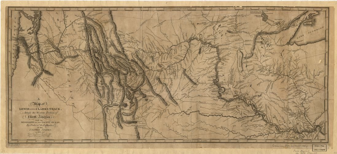
In autumn 1805, the Lewis and Clark expedition followed the Clearwater, Snake and Columbia river system toward the Pacific. These were not routes through an unpeopled landscape. Nez Perce guides Walamottinin and Tetoharsky helped the party, and communities along the rivers supplied knowledge, trade and assistance. The expedition reached the Snake–Columbia confluence on 16 October. A map printed in 1814 later gathered the journey into a continuous track. Its line makes travel look orderly, while the journals and Indigenous histories restore the encounters and decisions that made movement possible.
About the picture
The river network explains why following one channel led the party toward another. Printed in 1814, the map turns a journey made years earlier into a geographical summary. Its expedition track is easier to see than the local networks of knowledge and exchange on which the travellers depended.
The history behind it
Travel dates and publication dates
The map’s title refers to the expedition years 1804–1806, while the Library of Congress identifies the engraved publication as 1814. These dates describe different acts. The expedition traveled first; the published map subsequently presented a synthesis. Reading 1814 as the date of a particular river encounter would collapse the history of the journey into the history of the document.
A connected sequence, with named guides
For the late westbound leg in this packet, follow Clearwater, Snake, Columbia, then Pacific. The National Park Service places the Snake–Columbia encounter on 16 October 1805. Its account names Nez Perce guides Walamottinin and Tetoharsky, who brought the party along the rivers to communities familiar with the Columbia corridor. Yakama and Wanapam people welcomed the visitors at the confluence. Reconstructing this movement therefore includes the knowledge and relationships that made the connection possible, rather than treating the route as an empty line across unknown country.
What an engraved track cannot supply
The broad map helps locate the river chain, but it is not an hourly travel log. River order, direction of travel and an encounter date can be supported while an exact moving-time total remains unknown. A printed page also has its own orientation: reading labels from left to right is not a chronological method. Start with the requested direction and the documented connections, then use the larger geography to test the reconstruction.
A few things to read next
Books for a longer visit, and a few good places to start online. These are ordinary links, with no affiliate commission.
On the bookshelf
The Journals of the Lewis and Clark Expedition
Read the expedition journals in a scholarly, searchable digital edition.
Lewis and Clark Through Indian Eyes
Indigenous writers place the expedition within the histories of their own peoples.
Undaunted Courage
A narrative centred on Lewis; read alongside the Indigenous perspectives rather than as the only account.
Read online
Lewis and Clark Expedition
A starting point for names, dates and related subjects. Follow its references when you want to go further.
Confluence of the Columbia and Snake Rivers
The October 1805 arrival and the people living at the confluence.
Wanapum and the Lewis and Clark Expedition
A local Indigenous history that extends the story beyond the expedition’s track.
Lewis and Clark: To the Pacific
Maps and documents place the route within its historical setting.
Where the pictures come from
The original records and their individual rights statements are below. The pictures have not been generated or altered for the game.
A Map of Lewis and Clarks Track, published with the expedition history in 1814; the traveled years in its title are 1804–1806.
Library of Congress, Geography and Map Division, exhibition item 67 · 1814
Public domain in the United States: this map was published in 1814. Library of Congress reproduction credited; this is an independent age-based rights assessment.
Editorial paraphrase of National Park Service interpretation; a reading aid for reconstructing the recorded journey.
National Park Service / Data Barnacle source notes · 2026-11-01
Original editorial paraphrase of federal interpretive records; the historical map has separate rights.
History notes and reading lists prepared for Then & Found with AI assistance. The source institutions and authors are not sponsors or endorsers. Suggest a correction or another source


