Cities & construction 1900s
San Francisco after the earthquake and fires
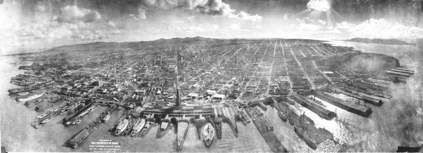
San Francisco’s disaster began with violent shaking on April 18, 1906, and continued as fires spread through the city. Broken water mains made the firefighting harder. A few weeks later, photographer George R. Lawrence raised a camera on a system of kites to make this sweeping view of the ruins. Streets and piers remain recognizable even where whole blocks have burned. The panorama gives an unusual sense of the city’s scale, while the histories of shelter, relief and rebuilding explain what this distant view cannot show about surviving the catastrophe.
About the picture
Lawrence made this panorama in May 1906, after the earthquake and the fires had done their damage. His kite-supported camera lifted the viewpoint above the streets. The surviving waterfront and regular street grid help the eye follow the city across areas where dense buildings had become broad fields of ruins.
The history behind it
What the archive establishes
USGS identifies this Lawrence panorama as San Francisco in ruins in May 1906, several weeks after the April earthquake and fires. That supports the first post-fire spring rather than active fire response, summer or autumn clearance, winter rebuilding or the first anniversary in 1907. These later stages are plausible recovery contexts, but their dates do not match this exposure. The waterfront and Union Ferry Building lie in the foreground, with the damaged city beyond. Surviving streets and piers coexist with extensive loss of buildings. USGS describes a kite-suspended camera, distinguishing this record from balloon photography, a powered-airplane survey, a fixed tower, a hilltop station or a ship’s mast. The image establishes elevation, not the support mechanism by itself; that precise finding comes from provenance. No claim about the cause or rebuilding schedule of every individual empty block is scored.
Date, place and phase
The source date is May 1906, several weeks after the April disaster. It precedes the summer, autumn, winter and first-anniversary recovery alternatives. USGS identifies the waterfront and Union Ferry Building with the damaged San Francisco city beyond, rather than another bay-area port. USGS identifies a kite-suspended camera. The elevated viewpoint alone cannot distinguish a kite from other proposed camera supports.
What the frame leaves open
The record dates the panorama to May 1906, not the first anniversary. Ruins and empty lots alone are not a reliable calendar. A pier can remain visible while having hidden damage. This packet is a panorama and provenance note, not a structural inspection. USGS identifies Lawrence’s kite-suspended camera. Other elevated survey methods are plausible in general, but not the recorded method for this artifact.
A few things to read next
Books for a longer visit, and a few good places to start online. These are ordinary links, with no affiliate commission.
On the bookshelf
A Paradise Built in Hell
Includes the earthquake in a wider study of how people organize after disasters.
A Crack in the Edge of the World
The 1906 catastrophe told alongside the geology beneath California.
California: A History
Places the disaster and rebuilding within the state’s longer urban history.
Read online
1906 San Francisco earthquake
A starting point for names, dates and related subjects. Follow its references when you want to go further.
The Great 1906 San Francisco Earthquake
The earthquake’s extent and why its effects reached far beyond San Francisco.
1906 Earthquake: Fire Fighting
How ruptured mains and spreading fires shaped the city’s emergency response.
Where the pictures come from
The original records and their individual rights statements are below. The pictures have not been generated or altered for the game.
San Francisco after the earthquake and fires of 1906, panorama by George R. Lawrence.
George R. Lawrence, via Wikimedia Commons · 1906
Public domain
History notes and reading lists prepared for Then & Found with AI assistance. The source institutions and authors are not sponsors or endorsers. Suggest a correction or another source


